THESE 15 Hikes in Yosemite National Park Are The Most Worth It
Yosemite National Park is known worldwide for its incredible granite cliffs, breathtaking vistas, and some of the most impressive waterfalls in North America.
In such a natural wonderland, it is hardly surprising that the hikes in Yosemite are also out of this world.
There are 750 miles of trails, from short paved paths leading to valley views to epic trails that take you up to waterfalls or along the valley floor. It can be hard to pick which to tackle.
So, we have made it a little easier for you to narrow down the best hikes in Yosemite!
Table of Contents
- Yosemite Hike Info:
- 1. Glacier Point
- 2. Wawona Meadow Loop
- 3. Bridalveil Fall Trail
- 4. Tenaya Lake Trail
- 5. Lower Yosemite Falls
- 6. Mirror Lake Loop
- 7. Sentinel Dome and Taft Point Loop
- 8. Wapama Falls
- 9. Tuolumne Grove Trail
- 10. Chilnualna Falls Trail
- 11. Mariposa Grove of Giant Sequoias
- 12. Clouds Rest
- 13. Half Dome
- 14. Vernal and Nevada Falls via the Mist Trail
- 15. Upper Yosemite Falls
Yosemite Hike Info:
- No dogs are allowed on the trails.
- A National Parks Pass or $35 entry fee is required.
- The trails below are listed from easy to moderate to hard
PARK PASS INFO:
Wait! You’ll need to pay a fee before entering Yosemite National Park.
You can purchase one for $35 per vehicle once you get here (good for seven consecutive days) or consider grabbing an America the Beautiful Pass if you’re visiting more national parks this year.
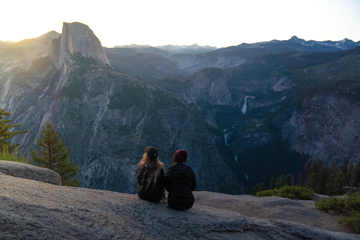
1. Glacier Point
Distance: 0.5 miles
Type of Trail: Loop
Difficulty: Easy
Elevation Gain: 49 feet
Trail Info
Glacier Point offers one of the most stunning spots in all of Yosemite, and the best thing is that you can pretty much drive to the view. A short and leisurely stroll along a paved walkway follows a large car park.

Once you reach the stunning viewpoint, the scene will take your breath away. You’ll be able to see almost the whole valley, with some of the best views of Tenaya Valley and Half Dome.
Not only is it one of the most rewarding hikes in Yosemite, but it is also one of the easiest.
2. Wawona Meadow Loop
Distance: 3.6 miles
Type of Trail: Loop
Difficulty: Easy
Elevation Gain: 239 feet
Trail Info
Some of the nicest hikes in Yosemite can be found before you even enter the valley, such as the Wawona Meadow Loop.
You won’t have to stretch and prepare for this one, as it is simply a beautiful flat stroll around Wawona Meadow.

Despite its easy grade, the whole route is beautiful,with plenty of tree cover to keep you out of the Californian sun.
If you feel like getting out and about in nature without building up a sweat, this is the Yosemite hike for you.
Make the short detour from the trailhead to check out the wooden covered bridge.
3. Bridalveil Fall Trail
Distance: 0.8 miles
Type of Trail: Out & Back
Difficulty: Easy
Elevation Gain: 114 feet
Trail Info
Want to get up close and personal with one of Yosmite’s most well-known waterfalls? Take the short, paved Bridalveil Fall Trail right up to the base of the 620-foot falls.

There is plenty of parking at the trailhead, and you should already be able to see the waterfall above you as you walk through the trees.
It is one of the few falls in the valley that flows throughout the year, but if you want to see it at its full flow, spring is the best time to take this hike.
4. Tenaya Lake Trail
Distance: 3.5 miles
Type of Trail: Out & Back
Difficulty: Easy
Elevation Gain: 183 feet
Trail Info
During the summer and fall, you’ll be able to experience the wonder of driving Tioga Pass Road, which goes right across the mountain and past the vivid blue Tenaya Lake.

The lake is beautiful, and this hike takes you along its shores, shaded by the forest the majority of the way. There are plenty of opportunities to dip your toes into the freezing lake, stop for a picnic on the beach, or even take out a kayak.
5. Lower Yosemite Falls
Distance: 1.2 miles
Type of Trail: Loop
Difficulty: Easy
Elevation Gain: 55 feet
Trail Info
Stretch your legs on this hike to Lower Yosemite Falls. As you walk towards the tallest waterfall in North America, you’ll get an impressive view of both tiers.
As you get closer, you’ll feel its full force as the water crashes down on the rocks. You’ll be able to get pretty close to the bottom of the waterfall, although the closer you get, the less of the upper falls you’ll be able to see.

The trail is relatively flat and either paved or boardwalked, making for an easy walk through the trees.
After you have had your fill of the waterfall, continue to the loop through the trees and over a bridge crossing the stream to complete one of the best hikes in Yosemite.
6. Mirror Lake Loop
Distance: 5 miles
Type of Trail: Loop
Difficulty: Easy
Elevation Gain: 301 feet
Trail Info
The Mirror Lake Loop takes you right along the base of Half Dome, giving you a unique perspective of this incredible rock formation.

You’ll make your way through Tenaya Canyon and around the beautiful Mirror Lake, where the reflection of the surrounding cliffs is breathtaking, although, in late summer, there may be very little water left.
7. Sentinel Dome and Taft Point Loop
Distance: 5.1 miles
Type of Trail: Loop
Difficulty: Moderate
Elevation Gain: 1,105 feet
Trail Info
This hike off Glacier Point Road ticks off two of the most incredible viewpoints in Yosemite. The loop starts by heading towards Sentinel Dome, a huge granite dome that sits high on the valley walls.

Make your way through the trees to reach the base of the dome, and then it’s just a short scramble up to the summit for 360-degree views of the valley, Half Dome, waterfalls, El Capitan, and more.
From there, rather than turning around, continue the hike until you reach Taft Point, avoiding the huge craggy fissures along the way.

Taft Point is not for the faint of heart, with limited railing and a huge drop-off, so stay back as you admire the vista from one of the most popular hikes in Yosemite.
8. Wapama Falls
Distance: 4.7 miles
Type of Trail: Out & Back
Difficulty: Moderate
Elevation Gain: 1,108 feet
Trail Info
The Wapama Falls Trail takes you out for the tourist crowd and over to the shores of the incredibly scenic Hetch Hetchy reservoir.
The trail takes you along the shoreline, with incredible views of the blue waters, until you reach Wapama Falls.

With relatively little elevation gain, this is a great hike in Yosemite to stretch your legs and see a little-visited part of the park.
If you visit in spring or early summer, chances are that Wapama Falls will not be the only waterfall you see cascading down the rocks.
9. Tuolumne Grove Trail
Distance: 2.7 miles
Type of Trail: Out & Back
Difficulty: Moderate
Elevation Gain: 623 feet
Trail Info
Escape the tourist crowds and visit a grove of over 20 mature giant sequoias and a “tree tunnel” on the Tuolumne Grove Trail just outside the valley.
The hike is rated as moderate for one reason: a steep path takes you down to the grove, and while it may seem easy on the way there, it can be tough on the way back up!

Here, a stunning nature trail winds through the trees, taking you to some of the best viewpoints where you can admire these giants up close.
10. Chilnualna Falls Trail
Distance: 7.7 miles
Type of Trail: Out & Back
Difficulty: Moderate
Elevation Gain: 2,201 feet
Trail Info
You don’t have to be in the valley to access some incredible hikes. We have to be honest; this is quite a steep one. You will start at the bottom of Chilnualna Falls and hike up to the top via a series of switchbacks, climbing 2200 feet.

The falls start with some smaller cascades and falls and finish with a more significant drop of 240 feet, totaling around 690 feet.
It’s quite a long hike, but it’s well worth it if you want to escape the tourist crowd and see some of Yosemite’s secret beauty.
11. Mariposa Grove of Giant Sequoias
Distance: 6.7 miles
Type of Trail: Out & Back
Difficulty: Moderate
Elevation Gain: 1,217 feet
Trail Info
It’s not all about granite cliffs and stunning views regarding hikes in Yosemite. It is also home to some of the biggest and oldest trees out there, giant sequoias.
In Mariposa Grove, there are around 300 of these giants, some of which are a staggering 2000 years old.

One of the best ways to see these magnificent trees is on the Mariposa Grove of Giant Sequios hike, which has too many highlights, but some of the best include the Fallen Monarch, Grizzly Giant, the California Tunnel Tree, and the Wawona Vista Point.
12. Clouds Rest
Distance: 13.5 miles
Type of Trail: Out & Back
Difficulty: Hard
Elevation Gain: 3,152 feet
Trail Info
Be prepared to clock some serious mileage on this hike, which takes you up high above the valley floor to Clouds Rest, a huge rock formation a short distance from Half Dome.
It’s a tough one, and in addition to the distance, there is a lot of elevation gain. At one point, you will gain 1000 feet in a mile.

The most common route to Clouds Rest starts along Tioga Road, and the closer you get to the summit, the more impressive the views are out over Tennaya Valley and Half Dome itself.
The end of this hike in Yosemite is scary, as you’ll be hiking along a narrow ridge with drops on either side, so it isn’t for the faint of heart.
13. Half Dome
Distance: 16.5 miles
Type of Trail: Out & Back
Difficulty: Hard
Elevation Gain: 5,305 feet
Trail Info
The hike up to Half Dome is among the most challenging in Yosemite, so tackle it only if you are prepared.
However, if you decide to go for it, you are in for a hike of your life. You’ll head 4800 feet high above the valley floor.
The hike starts with a very steep climb up to the spectacular Vernal Falls, followed by Nevada Falls, but you don’t stop there.

The hike continues to climb until eventually you reach the base of Half Dome, and the legendary cables part of the climb begins.
The cables are embedded into the granite dome, and it’s a scary climb up to the summit but an even more terrifying one on the way back down due to the 45/55 degree grade!
If the above hike is a bit much, you can always camp closer to start the hike. This cuts off a lot of mileage and most of the elevation gain, but you will still experience the cables.
14. Vernal and Nevada Falls via the Mist Trail
Distance: 6.4 miles
Type of Trail: Loop
Difficulty: Hard
Elevation Gain: 2,208 feet
Trail Info
This epic hike is likely one of the most well-known hikes in Yosemite, featuring two incredible waterfalls and impressive views out over the park. It’s certainly a personal favorite!

You’ll start climbing from the get-go, with incredible views of the surrounding granite cliffs, until you come to a wooden bridge, and this is where you’ll get your first glimpse of the huge Vernal Falls.
From the top of the fall, continue heading up until you reach Nevada Falls.

If you are not able to do the whole thing, you can always turn around at Vernal Falls, but this time, take the John Muir trail to make a nice loop and see Nevada Falls from afar.
15. Upper Yosemite Falls
Distance: 6.6 miles
Type of Trail: Out & Back
Difficulty: Hard
Elevation Gain: 3,254 feet
Trail Info
Yosemite Falls is one of the most spectacular waterfalls in the world, so it is hardly surprising that hiking to the Upper Falls is one of the most dazzling hikes, but we better mention that it is tough!

You’ll tackle many switchbacks, but you’ll be shaded by trees the majority of the way, and there are many places where you can rest and enjoy the sights.
Once you reach the summit, you’ll have incredible views looking down from the 2425-foot falls. These views are breathtaking, with views of the valley, Sentinel Dome, Half Dome, and, of course, the incredible waterfall.

If the whole Upper Yosemite Falls trail is a bit too long, you can always do the Columbia Rock Trail as an alternative, which still takes you high above the valley floor via the same trail, you’ll make Columbia Rock your final destination.
Check out our other guides to Yosemite:
- Things To Do in Yosemite: 26 Can’t-Miss Spots!
- 15 Best Hikes in Yosemite National Park
- Sentinel Dome and Taft Point Loop Hike
- Vernal Falls Hike—3 Ways to Hike Up!
- Where to Stay in Yosemite: BEST Areas, Camping and Lodging
- Waterfalls in Yosemite National Park: 8 BEST!
- Glacier Point Road: What to Know
We hope this helped you plan which hikes in Yosemite National Park you want to tackle!