
This free L.A. County park hid an outlaw in 1874, and Captain Kirk fought an alien on it a century later
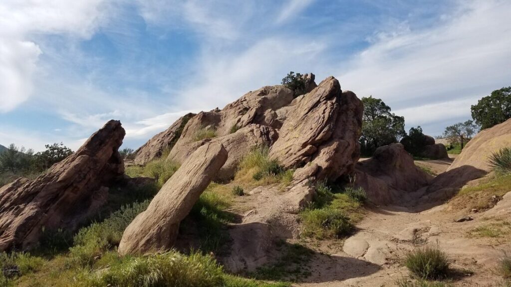
Forty-five minutes north of downtown LA, a set of sandstone slabs juts out of the ground at a 65-degree tilt, like the earth cracked open and forgot to close back up. It’s called Vasquez Rocks, and it’s been playing alien planets on TV since before your parents were born.
The park is named after Tiburcio Vásquez, a 19th-century outlaw who used these formations to dodge California law enforcement in 1873 and 1874. No entrance fee, no gate, no reservation — just 932 acres of public land that looks like it belongs on Mars.
Psst — we made you a West Coast Adventure Map. Nearly 1,900 of our favorite spots, already pinned, ready to load into Google Maps in two clicks — grab it here.
The bandit who gave it his name
Vásquez was one of California’s most notorious bandidos, and these jagged rocks made a genuinely useful hideout — plenty of crevices, high ground, and nowhere for a posse to sneak up on him unnoticed. He used them to evade law enforcement in 1873 and 1874, and the name stuck for good.
📍 GET THE ULTIMATE CALIFORNIA MAP 🗺️
Get our curated list of the best adventures and things to do north of LA loaded onto your maps with just two clicks!
✅ Waterfalls ✅ Hikes ✅ Viewpoints
✅ National Parks ✅ 1400+ Pins

Hollywood found it a few decades later
Vasquez Rocks sits inside what the film industry calls the “studio zone,” meaning productions could shoot here without paying actors and crew extra travel money. That alone made it a magnet for low-budget productions starting in the 1930s — it stood in for Tibet in 1935’s Werewolf of London before becoming a go-to backdrop for Westerns through the ’40s and ’50s.
Then Star Trek showed up. The original series filmed here at least four times starting in 1966 — first for “Shore Leave,” then “Arena” and “The Alternative Factor” that same November — and the crew nicknamed it Kirk’s Rock. It kept coming back for Star Trek IV, the 2009 reboot, The Next Generation, Voyager, Enterprise, and Picard, which finally let the rocks play themselves instead of yet another alien world.
An earthquake fault, on display
The tilt is the whole point. These sandstone layers formed underground roughly 25 million years ago, then got shoved up and sideways by the Elkhorn Fault, an offshoot of the San Andreas that runs directly through the park.
Stand at the base of the main formation and you’re looking at rock that used to lie flat, now standing on end — a geology lesson you can touch, no textbook required. A handful of other faults, including the Pelona and San Gabriel, sit close enough to make this one of the more legible fault zones in Southern California.
Hiking it without melting
The main loop around the formation covers a little under two miles with barely any climbing, easy enough for flip-flops if you’re just here for photos. A short stretch of the Pacific Crest Trail crosses through the park too, so you can extend the walk if you want more miles under your boots.
This is high desert, and it turns brutal fast once the sun’s up — come at first light in summer if you don’t want to melt halfway through your visit. Dogs are welcome on leash, and the small nature center by the entrance has restrooms and an exhibit on the park’s geology and film history, open Tuesday through Sunday.
If tilted rock and movie trivia is your thing, Alabama Hills near Lone Pine is the state’s other legendary rock-and-camera playground, just a few hours further north.
Next time someone claims they’ve never stood on an alien planet, ask if they’ve been to LA County. They probably just didn’t realize it.
Trip tips: grab a rental car for the drive out from LA, and if you’re turning it into an Antelope Valley weekend, lock in a hotel in Santa Clarita or Palmdale first.
Rules and fees change — always confirm current requirements before you go.