
Highway 1 kept crumbling off this Pacifica cliff, so California built tunnels and gave the old road to walkers
Some roads get a scenic overlook. This one got retired. For decades, a stretch of Highway 1 just south of Pacifica kept peeling off its cliff toward the Pacific, and today it’s one of the easiest, most jaw-dropping walks on the whole San Mateo coast.
No cars, no traffic, no white-knuckle curves. Just a wide ribbon of old pavement hanging off a mountain, with seabirds wheeling below you and nothing but ocean out to the horizon.
Psst, we made you a West Coast Adventure Map. Nearly 1,900 of our favorite spots, already pinned, ready to load into Google Maps in two clicks: grab it here.
Why they call it Devil’s Slide
The name isn’t marketing. State Route 1 was finished through here in 1937, and by 1940 it had closed at Devil’s Slide for the first time, beaten by the erosion and landslides that have plagued this slope ever since.
It never really stopped misbehaving. A big slide in 1995 shut the road down for months, and in April 2006 cracks opened up in the roadbed and closed it again for about five months.
If you lived on the coastside, every one of those closures was a serious headache. Can you imagine your commute depending on whether a mountain felt like staying put?
📍 GET THE ULTIMATE CALIFORNIA MAP 🗺️
Get our curated list of the best adventures and things to do north of LA loaded onto your maps with just two clicks!
✅ Waterfalls ✅ Hikes ✅ Viewpoints
✅ National Parks ✅ 1400+ Pins

The tunnel fight that took decades
The state’s first big fix was a freeway bypass around the slide, and conservation groups sued over it back in 1971. Critics argued the plan would leave a permanent scar on Montara Mountain and the state park beside it.
The fight dragged on for a quarter century. In November 1996, San Mateo County voters passed Measure T, known as the Tunnel Initiative, with more than 73% of the vote, and in March 2013 the Tom Lantos Tunnels finally opened and sent traffic straight through the hillside.
That left a mile-plus of perfectly good highway with nowhere to go. A year later, in March 2014, it reopened as the Devil’s Slide Trail.
What the walk is actually like
Here’s the beauty of it: this is old Highway 1, so it’s wide, paved, and easy. The trail runs 1.3 miles each way, about 2.6 miles round trip, with a few hundred feet of gentle climbing and separate lanes for walkers and bikes.
I’ve walked the whole thing in flip-flops (yes, really), which tells you everything about the difficulty level. Wear real shoes anyway, but you can leave the trekking poles at home.

The views are the whole show. Cliffs drop straight into churning surf, benches and coin-operated viewers line the route, and interpretive panels fill you in on the geology and wildlife as you go.
Bring binoculars! Brown pelicans, peregrine falcons, pigeon guillemots and Brandt’s cormorants all work these cliffs, and whales and seals show up offshore too. Our full Devil’s Slide Trail guide has more on the route.
The graffiti bunker on the bluff
Near the south end, a concrete bunker clings to a bluff above the ocean, covered top to bottom in graffiti. It was part of a World War II lookout and triangulation station for San Francisco’s harbor defenses, where crews used binoculars and compasses to track ships offshore.
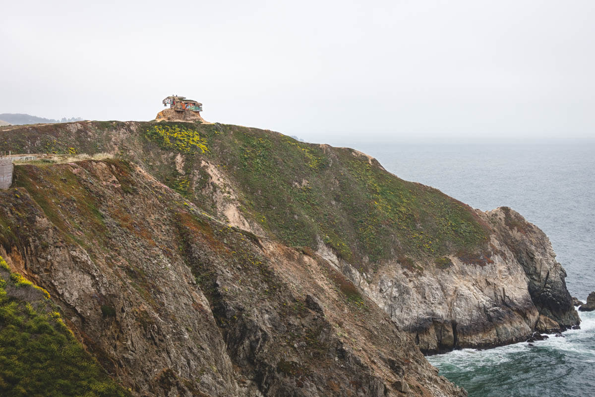
It’s one of the most photographed spots on this stretch of coast, and it’s best admired from a distance. The ground around it is unstable, the trail rules ban wandering off designated trails, and these cliffs have a long track record of giving way.
When to go and where to park
Free parking lots sit at both ends of the trail, and they’re small, so weekends reward early birds. The lots open at 8 a.m. and close at 6 p.m. through November 1, then at 5 p.m. through the winter.
My pick? Go on a weekday afternoon, walk south, and turn around when the light starts going gold. Just watch the clock so you’re back at the car before the lot closes.
Leashed dogs are welcome, and there are restrooms and a water fountain on site. San Mateo County Parks posts closures and advisories online, so take a quick look before you head out.
🏨 Need a place to crash nearby?
From rustic cabins to boutique inns—check prices and availability in just a click.
Make it a coastside day
Just north of the trail, Pacifica State Beach is home to what might be the most scenic Taco Bell on the planet. Our post on the Pacifica Taco Bell explains why this is a completely legitimate detour.

Heading south instead? Half Moon Bay is a short drive down Highway 1, with plenty of things to do in Half Moon Bay and more hikes in Half Moon Bay to fill out the weekend.
Trip tips: grab a rental car to get out here, lock in your hotel before the good rooms are gone, or skip both and book a camper van instead.
So, have you walked Devil’s Slide yet, or have you only ever zipped through the tunnels? Tell us in the comments, and let us know which retired road we should walk next.
Rules and fees change, so always confirm current requirements before you go.

Yes, l used to commute to tge City via the old Highway before the tunnel. It shave minutes off the rugged commute when the tunnel opened. Since the SMC Parks Department opened the trail
I have been on it several times over the years. Once when it was windy, foggy and very cold. And another time, early in the morning, when there were bits of chert that was crumbling from the hillside. then, once a huge boulder came down nearly blocking lanes, but luckily it landed in the North parking lot, just before the tunnel entrance! I don’t think l haven’t there since.