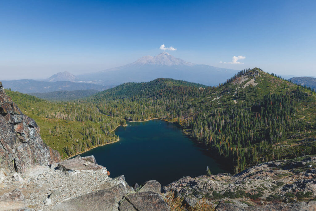
This lake near Mount Shasta is named for its heart shape, and you can’t see it from the shore
Heart Lake has a great name and a terrible first impression. You’ll stand right on its shore, look around, and wonder if you took a wrong turn.
Then you scramble up a pile of rocks behind it, turn around, and get it. Mount Shasta fills the horizon, the forest drops away below you, and the shape finally clicks. It’s one of our favorite short hikes in Northern California, and October is a great month to do it.
Psst — we made you a West Coast Adventure Map. Nearly 1,900 of our favorite spots, already pinned, ready to load into Google Maps in two clicks — grab it here.
It starts at a lake a glacier carved out
The trailhead sits at Castle Lake, about 10 miles southwest of the town of Mount Shasta in the Shasta-Trinity National Forest. Take Exit 736 off I-5 and follow Castle Lake Road until it ends.
Castle Lake is a glacial cirque lake, a bowl scooped out of the mountain during the last ice age. It covers 47 acres at 5,440 feet, drops to 110 feet deep, and has granite cliffs walling in its southern shore. The water is so clear you’ll want to jump in before you’ve even started hiking.
Fun bonus fact: UC Davis scientists have been studying this lake since 1959. So yes, the pretty lake you’re about to walk past is also a long-running science project.
📍 GET THE ULTIMATE CALIFORNIA MAP 🗺️
Get our curated list of the best adventures and things to do north of LA loaded onto your maps with just two clicks!
✅ Waterfalls ✅ Hikes ✅ Viewpoints
✅ National Parks ✅ 1400+ Pins
The climb is short, but it climbs
Here’s the deal: 2 miles round trip, about 721 feet of elevation gain, out and back, rated moderate. That’s not a lot of distance, but most of the climbing is packed in, so you’ll feel it.
The trail follows the east shore of Castle Lake through the trees, then starts switchbacking uphill. Those switchbacks are fairly new. In 2021, volunteers from the Mount Shasta Trail Association rerouted the old steep, eroded sections, so the grade is a lot friendlier than it used to be.

Keep looking back as you climb. Castle Lake gets bluer and bluer below you, and Mount Shasta keeps popping up over the ridgeline like it’s checking on your progress.
Most of the upper trail is exposed, and the junctions near the top aren’t well signed. Download an offline map before you lose cell service, because you will lose cell service.
So where’s the heart?
When we got to Heart Lake, we stood on the shore genuinely confused. Up close, it just looks like a small, pretty alpine pond tucked into the rocks.

The trick is height. Keep following the trail past the lake toward the rocky hill in front of you, then scramble up for the view. From up there, the shapes and the scale finally make sense, with Mount Shasta, Black Butte, and Castle Lake all spread out below.
My take? That rock is the real summit of this hike, so don’t snap one photo at the shoreline and head back down.
We wrote up every junction and turn in our full Heart Lake Trail guide, including exactly where to leave the main path for that viewpoint.
Why October is the move
Trail season up here runs from May through November, and once the snow shows up, Castle Lake Road and the trail turn into winter terrain. Right now you’re catching the tail end of the hiking window, with the summer swim crowds long gone.
Pack a warm layer even if it’s sunny in town, because I’d never trust a fall morning at 6,000 feet. Fall is also wildfire season in Northern California, so check the Shasta-Trinity National Forest’s alerts page for closures and road conditions before you drive up.
Good news on cost: there’s no fee and no permit needed to day hike from Castle Lake.
Turn it into a whole day
Still have gas in the tank? A side trail branches off to Little Castle Lake, which bumps the total to about 2.9 miles with an extra 260-foot drop and climb back out.
If your legs are already done, skip it. The view above Heart Lake is the headliner.
Back at the bottom, Castle Lake itself is the reward. Paddle it, picnic on the shore, or just sit on a log and soak up those granite cliffs. There’s also a small campground 0.3 miles down the road if you want to stay close.
For something with more amenities, we stayed at Lake Siskiyou, about 15 minutes away, and loved having Mount Shasta right over the water. Stack this hike with a few more Mount Shasta hikes or other things to do in Mount Shasta and you’ve got yourself a fall weekend.
So be honest: would you have turned around at the shoreline, or are you the type who always climbs the extra rock? Tell us in the comments.
Trip tips: grab a rental car to get out here, lock in your hotel before the good rooms are gone, or skip both and book a camper van instead.
Rules and fees change — always confirm current requirements before you go.